City initialization and methods
[1]:
import os
import pandas as pd
import geopandas as gpd

example_data_path = "data"
Initialization
Use the results obtained from the blocksnet.preprocessing or use your own data.
[2]:
blocks = gpd.read_parquet(os.path.join(example_data_path, "blocks.parquet"))
acc_mx = pd.read_pickle(os.path.join(example_data_path, "acc_mx.pickle"))
[3]:
from blocksnet.models import City

city = City(
  blocks=blocks,
  acc_mx=acc_mx,
)
Print city model to get the information about existing service types, CRS and blocks count
[4]:
print(city)
CRS : EPSG:32636
Blocks : 16320
Service types : 0/66
Buildings : 0
Services : 0
Update layers
Update the information about services and buildings using .update_buildings() and .update_services().
It is IMPORTANT to update buildings first, because they serve as container for some kinds of services.
Specification for buildings is described in the blocksnet.models.city.Building
[5]:
buildings = gpd.read_parquet(os.path.join(example_data_path, "platform/buildings.parquet")).to_crs(city.crs)
[6]:
buildings = buildings.rename(columns={
  'population_balanced': 'population',
  'building_area': 'footprint_area',
})
buildings = buildings.fillna(0)
buildings['number_of_floors'] = buildings.apply(
  lambda x : x['storeys_count'] if x['storeys_count']>1 else 1,
  axis=1
)
buildings['build_floor_area'] = buildings['footprint_area']*buildings['number_of_floors']
buildings['business_area'] = buildings['build_floor_area'] - buildings['living_area']
[7]:
bad_buildings = city.update_buildings(buildings)
2024-09-23 01:08:01.221 | INFO     | blocksnet.models.city:update_buildings:1237 - Removing existing blocks from the model
2024-09-23 01:08:01.257 | INFO     | blocksnet.models.city:update_buildings:1241 - Joining buildings and blocks
2024-09-23 01:08:22.054 | WARNING  | blocksnet.models.city:update_buildings:1253 - 1721 buildings did not intersect any block
Update blocks buildings: 100%|██████████| 6109/6109 [00:19<00:00, 313.11it/s]
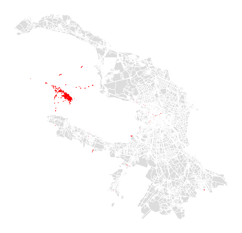
Visualize buildings that did not intersect any block
[8]:
ax = blocks.plot(color='#ddd', figsize=(10,10))
bad_buildings.plot(linewidth=1, edgecolor='red', color='red', ax=ax).set_axis_off()
Specification is described in the blocksnet.models.city.Service
[14]:
from tqdm import tqdm

for service_type in tqdm(city.service_types):
  try:
    services_gdf = gpd.read_parquet(os.path.join(example_data_path, f"platform/{service_type.name}.parquet")).to_crs(city.crs)
  except:
    continue
  services_gdf['area'] = services_gdf.geometry.area
  services_gdf.geometry = services_gdf.representative_point()
  if not 'capacity' in services_gdf.columns:
    services_gdf['capacity'] = 0
  else:
    services_gdf['capacity'] = services_gdf['capacity'].apply(lambda c : 0 if c is None else int(c))
  city.update_services(service_type, services_gdf[['geometry', 'area', 'capacity']])
100%|██████████| 66/66 [02:44<00:00, 2.50s/it]
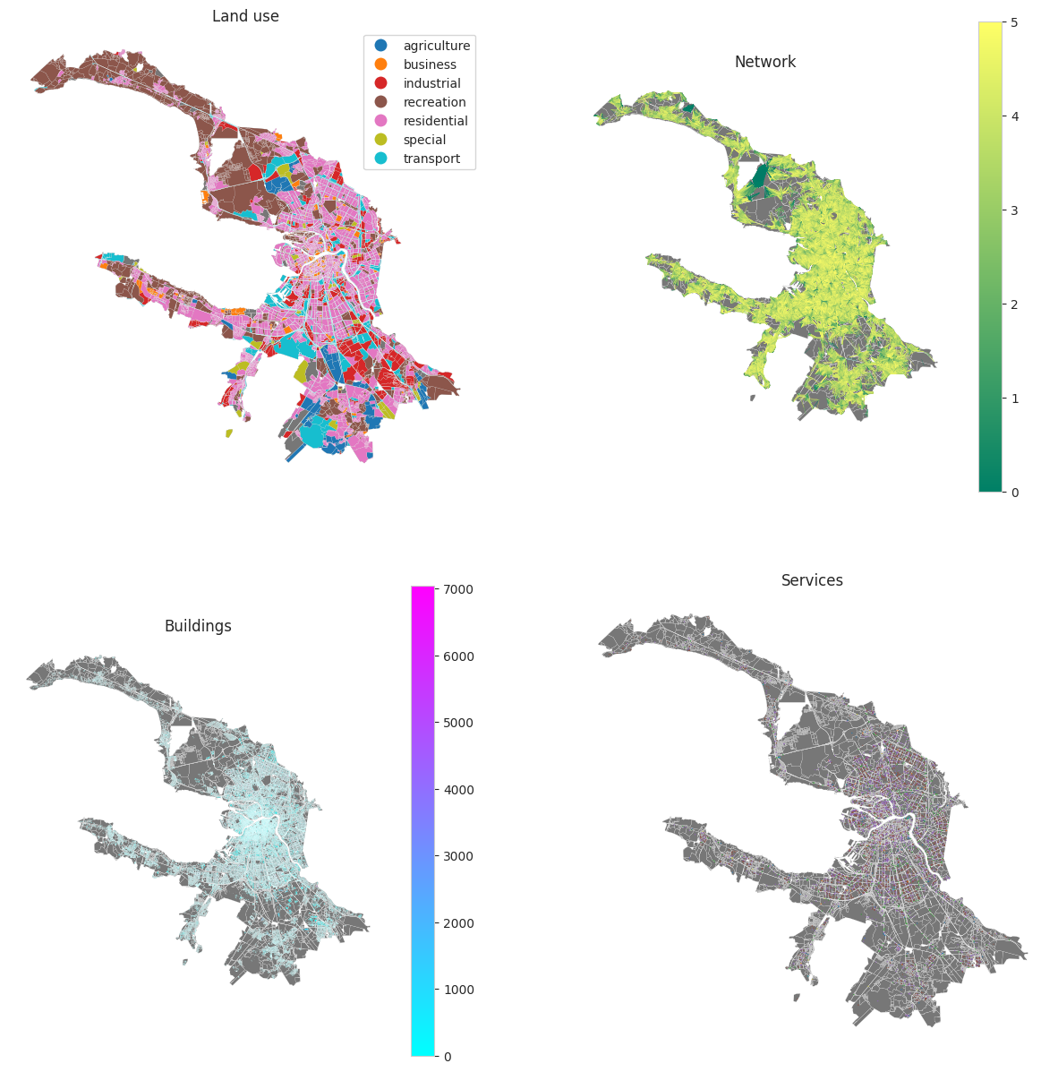
Visualize the model using .plot() method. If you don’t have LandUse in your blocks, you can update the info later via .update_land_use() method.
[11]:
city.plot(max_travel_time=5)
Methods and other ways to operate the City model
Save city model to file with .to_pickle() so we can use it later
[15]:
city.to_pickle(os.path.join(example_data_path, 'model.pickle'))
Block within the city model can be obtained via id (int)
[ ]:
block = city[123]
block
Block(id=123, geometry=<POLYGON ((346460.223 6649125.497, 346465.461 6649128.123, 346465.462 664912...>, land_use=<LandUse.MIXED_USE: 'mixed_use'>, buildings=None, services={}, city=<blocksnet.models.city.City object at 0x7f12698ac670>)
Get indicators for the block.
[32]:
res = block.to_dict()
for key,value in res.items():
  if isinstance(value, float) : res[key]=round(res[key],2)
res
[32]:
{'id': 2,
 'geometry': <POLYGON ((353934.329 6625429.433, 353923.453 6625429.324, 353918.105 662542...>,
 'land_use': 'recreation',
 'is_living': True,
 'build_floor_area': 1173.87,
 'living_demand': 58.69,
 'living_area': 821.71,
 'share_living': 0.71,
 'business_area': 352.16,
 'share_business': 0.3,
 'site_area': 363005.82,
 'population': 14,
 'footprint_area': 1163.48,
 'fsi': 0.0,
 'gsi': 0.0,
 'l': 1.01,
 'osr': 308.25,
 'mxi': 0.7,
 'capacity_fuel': 501}
Get available ServiceTypes for current Block LandUse
[33]:
available_service_types = block.land_use_service_types
[st.name for st in available_service_types]
[33]:
['pitch',
 'swimming_pool',
 'stadium',
 'theatre',
 'museum',
 'cinema',
 'bowling_alley',
 'university',
 'beach',
 'train_building',
 'subway_entrance',
 'multifunctional_center',
 'park',
 'hotel',
 'circus',
 'post',
 'police',
 'dog_park',
 'hostel',
 'guest_house',
 'reserve',
 'sanatorium',
 'embankment',
 'wastewater_plant',
 'water_works',
 'substation',
 'train_station',
 'bus_station',
 'bus_stop',
 'pier']
ServiceType can be obtained the same way by name (str). The information about accessibility, demand, bricks can be obtained this way.
[34]:
service_type = city['school']
service_type
[34]:
ServiceType(code='3.5.1', name='school', accessibility=15, demand=120, land_use=[<LandUse.RESIDENTIAL: 'residential'>, <LandUse.BUSINESS: 'business'>], bricks=[ServiceBrick(capacity=250, area=3200.0, is_integrated=False, parking_area=0.0), ServiceBrick(capacity=300, area=4000.0, is_integrated=False, parking_area=0.0), ServiceBrick(capacity=600, area=8200.0, is_integrated=False, parking_area=0.0), ServiceBrick(capacity=1100, area=13000.0, is_integrated=False, parking_area=0.0), ServiceBrick(capacity=250, area=2200.0, is_integrated=True, parking_area=200.0), ServiceBrick(capacity=300, area=3600.0, is_integrated=True, parking_area=300.0), ServiceBrick(capacity=600, area=7100.0, is_integrated=True, parking_area=600.0)])
Add new ServiceType to the City model list
[35]:
from blocksnet import ServiceType

city.add_service_type(ServiceType(code='', name='internet_cafe', accessibility=30, demand=100, bricks=[]))
city['internet_cafe']
[35]:
ServiceType(code='', name='internet_cafe', accessibility=30, demand=100, land_use=[], bricks=[])
Get the distance (min) between two city Blocks
[36]:
city.get_distance(0, 1)
[36]:
7.4
Get blocks GeoDataFrame via .get_blocks_gdf() method. Use simplify=True to exclude information about services.
[37]:
blocks_gdf = city.get_blocks_gdf(simplify=True)
blocks_gdf.head()
[37]:
| geometry | land_use | is_living | build_floor_area | living_demand | living_area | share_living | business_area | share_business | site_area | population | footprint_area | fsi | gsi | l | osr | mxi | |
|---|---|---|---|---|---|---|---|---|---|---|---|---|---|---|---|---|---|
| id | |||||||||||||||||
| 0 | POLYGON ((354918.622 6625258.829, 354901.464 6... | None | True | 43840.686518 | 50.641057 | 30688.480678 | 2.199357 | 13152.205840 | 0.942581 | 8.044667e+05 | 606 | 13953.390266 | 0.054497 | 0.017345 | 3.141938 | 18.031500 | 0.700000 |
| 1 | POLYGON ((355412.142 6623378.149, 355411.700 6... | transport | True | 10294.395525 | 53.114392 | 2177.690063 | 0.431105 | 8116.705462 | 1.606820 | 2.317313e+04 | 41 | 5051.410558 | 0.444238 | 0.217986 | 2.037925 | 1.760348 | 0.211541 |
| 2 | POLYGON ((353934.329 6625429.433, 353923.453 6... | recreation | True | 1173.871643 | 58.693582 | 821.710142 | 0.706252 | 352.161501 | 0.302679 | 3.630058e+05 | 14 | 1163.480697 | 0.003234 | 0.003205 | 1.008931 | 308.246934 | 0.700000 |
| 3 | POLYGON ((355099.099 6623847.765, 355074.808 6... | residential | True | 46303.954706 | 52.660044 | 30595.485797 | 2.760046 | 15708.468909 | 1.417075 | 1.964145e+05 | 581 | 11085.135352 | 0.235746 | 0.056437 | 4.177121 | 4.002452 | 0.660753 |
| 4 | POLYGON ((352766.168 6621954.748, 352744.412 6... | recreation | True | 153749.574111 | 53.097680 | 106407.750936 | 2.352959 | 47341.823175 | 1.046854 | 1.781752e+06 | 2004 | 45222.959595 | 0.086291 | 0.025381 | 3.399812 | 11.294526 | 0.692085 |
The same way buildings and services GeoDataFrames can be obtained with:
.get_buildings_gdf().get_services_gdf()
[38]:
buildings_gdf = city.get_buildings_gdf()
buildings_gdf.head()
[38]:
| block_id | geometry | population | footprint_area | build_floor_area | living_area | non_living_area | number_of_floors | is_living | |
|---|---|---|---|---|---|---|---|---|---|
| id | |||||||||
| 158414 | 0 | POLYGON ((354964.060 6625185.771, 354959.684 6... | 0 | 15.030958 | 15.035234 | 10.524664 | 4.510571 | 1 | True |
| 150194 | 0 | POLYGON ((355008.167 6625301.606, 355012.344 6... | 0 | 22.185639 | 22.191954 | 15.534368 | 6.657586 | 1 | True |
| 58769 | 0 | POLYGON ((354878.941 6625544.327, 354882.984 6... | 0 | 31.264070 | 31.272943 | 21.891060 | 9.381884 | 1 | True |
| 158321 | 0 | POLYGON ((355037.286 6624978.295, 355060.347 6... | 0 | 158.324760 | 158.369888 | 110.858925 | 47.510963 | 1 | True |
| 36319 | 0 | POLYGON ((354643.688 6625735.942, 354657.286 6... | 1 | 192.709820 | 192.764221 | 134.934952 | 57.829269 | 1 | True |
[39]:
services_gdf = city.get_services_gdf()
services_gdf.head()
[39]:
| geometry | block_id | building_id | service_type | capacity | area | is_integrated | |
|---|---|---|---|---|---|---|---|
| 0 | POINT (353603.237 6625736.175) | 2 | 77507.0 | fuel | 501 | 80.0 | True |
| 1 | POINT (355093.541 6624021.861) | 3 | NaN | pitch | 75 | 8000.0 | False |
| 2 | POINT (355171.604 6624273.791) | 3 | 158369.0 | fuel | 261 | 80.0 | True |
| 3 | POINT (353025.189 6622629.138) | 4 | NaN | pitch | 165 | 8000.0 | False |
| 4 | POINT (353416.159 6622235.257) | 4 | NaN | parking | 52 | 1250.0 | False |